Maps Interest Me

Luxor is ancient Thebes and has a fascinating past. Share your knowledge or ask your questions here.

Moderators: DJKeefy, 4u Network

Post Reply
User avatar
Hafiz
V.I.P
V.I.P
Posts: 1284
Joined: Mon Feb 20, 2012 4:23 pm
Has thanked: 614 times
Been thanked: 632 times
Gender:
Australia

Maps Interest Me

Post by Hafiz »

Maps interest me, especially historical maps which show the changing human and physical landscape. The ones of Luxor in the last 100 or so years show the effects of the Aswan Dam and the impact of the Nile floods on islands and bank perimeters. The maps are pretty limited and often touristic so working out what the place actually looked and functioned like is better by using the maps together with contemporary photographs.

Its also true that maps give a partial view particularly because until the 2nd Aswan Dam the Nile wrecked a lot of havoc and changed the shape of the banks and islands.

The older maps suggest there was little physical and human development until after the 1920’s – particularly on the west bank - either in terms of the city, villages or agriculture – but its hard to be certain. In general for the period prior to about 1900 there are more photographs than maps and I have used the former to try to develop a picture of the natural and man-made structures of that period. After 1900 western maps become more frequent which is odd because in the classical Muslim period cartography was a stand-out achievement – but maybe not in backward Egypt.

I imagine there are a few on this forum who have been long term residents of Luxor who will have more information on these issues, recollections and maybe better maps/photos. Please feel free to contribute.

The post is long, boring and detailed – so be warned. Some may want to read a 5 liner.

Here is what I think I have been able to work out:

Ancient maps exist but don’t provide very reliable information. Old western maps until quite recently were very imprecise – particularly on detail and it’s the Great Captain Cook who after 1770 brings his mind to French Enlightenment (a foreign disease) precision to naval maps/cartography. He was a failure and got no Imperial Orders or Admiralships that heroic and brave Royals now get. Justice for the best. Napoleon did maps of the Luxor area but the Government of France hasn’t put them on-line and what I’ve seen are imprecise.

Whatever the maps say the early photography shows that the Nile was wide – at least for some of the year. Here is a photo from 1853-54 by the American/French John Beasley Greene, an archaeologist, taken from the East Bank, probably near the Luxor Temple, showing the then Ghezireh Island in the middle ground and the western hills beyond. At this stage there was another branch of the Nile on the west side of that island/another branch for part of the year.

Image

(part of a small collection of historic ME photos sold recently in London)

As most know the Nile levels once varied wildly but I was surprised to see this Luxor river bank photographed by Beato from 1859 (I’m not too sure of the date) near the Luxor Temple.
Image

There wasn’t a lot happening on the west bank nor much evidence of human habitation – here is a photo by Frith from 1856-60 looking towards the Nile from Habu with the Colossi in the middle ground:
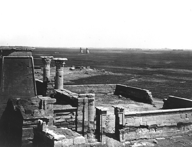
Image

This is consistent with a much earlier litho from 1803 by Vivant Denon which shows little permanent human habitation in this area:
Image

Its probable that in part of whole this plain was flooded for part of the year to produce one crop but preventing permanent structures.

Another photo by Beato of Memnon probably from around 1870 suggests that the area around the Colossi was not farmed or irrigated on any permanent basis:
Image

But another one taken by the US photographer Eliot Elisofon shows that as late as around 1942 Nile flooding (unclear whether this was a standard or exceptional flood year) of the same area was extreme which suggests that the area might have been dry and barren for some of the year but flooding would have given them at least one crop (but there is little visible evidence of tilling):
Image

This flooding might explain why housing, and presumably a permanent population, on the West Bank might have been sparse. It also raises questions (which I can’t answer) about the road and rail infrastructure on the West Bank which was developed over the next 70 years (see below). For example there appears to have been a detailed network of probably narrow gauge rail to deal with the sugar cane which, I think, was a major crop before WW2. This photo makes you realize how limited the control the 1st Aswan Dam (finished 1902) gave over Nile flooding and how necessary the 2nd one was to create permanent farming land.

A photo from circa 1870, which I think is of the half covered Luxor Temple, shows little modern development on the East Bank:
Image

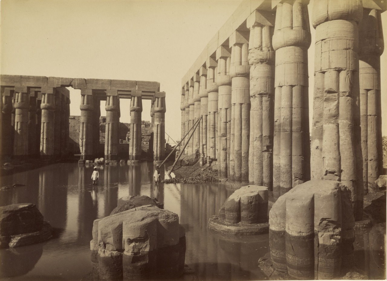
An 1875 photo by Beato of the flooded courtyard of Amenhotep III in the Luxor Temple shows you why static maps can be deceptive and show little of the actual seasonal conditions:
Image

Image

An 1871 photo by Beato, probably of the Luxor Temple, shows the Nile at a low point and limited building development on the east in this area.

Image

To add a bit more confusion here is another photo from Beato – (attribution dates for this photo vary wildly but around 1880) apparently of a village on the East Bank – which illustrates that the traditional housing was very distinctive in design and that the canals on the maps might have been less engineered/man made than you would think:
Image

Another photograph by an unknown photographer from 1865-75 of an Upper Egyptian house in an unknown village shows detail of the similar and now discontinued traditional architectural style:
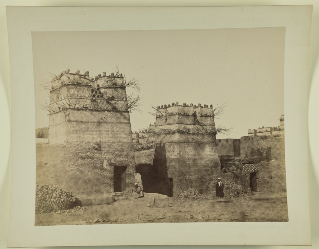
Image

A fuzzy 1888 UK map of the Karnak Temple has the Avenue of the Sphinxes connecting the Karnak and Luxor Temples - which is unexpected. I thought that until Governor Farag they barely existed. The map is a bit odd with a very strange Nile shoreline and creeks on the east bank. There is little other info in the map.
Image

The city may look ‘developed’ on a map but here is a photograph by Beato from sometime around 1860’s -70’s which shows the area around the Luxor Temple (or is it Karnak- I think it’s the former) to be not built up – note the high banks:
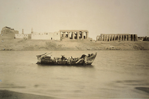
Image

Image

A rough map from a 1896 book also has the Sphinx Avenue on the East and a creek/canal on the West Bank running from the hills into the Nile and starting around Habu. There are two large islands opposite the city and Karnak and no road system shown but I don’t think this map aims to be comprehensive – I think it aims to show mainly archaeology.
Image
A US 1905 map shows little city or agricultural development. There is one large north-south channel on the west bank which may have been for irrigation and, interestingly, a ‘modern channel’ running irregularly to the Nile from a ‘lake’ in the Birket Habu area (see above). There are islands in the Nile and very different West bank perimeters than today – but more of that later. The city looks small and compact.
Image

Unlike modern Egyptian tourism the entrepreneurs in the 19th century tried to match good architecture with traditional themes – rather than go for the Las Vegas/Louis Farouk style. Here is Grande Pension de famille à Louxor ; circa 1906. It used to be located about 100 metres from the Nile just north of the ‘English Church’ and is a good example of how even humble 3 star businesses used to be well designed. But not nowadays.
Image

By 1908, after the First Dam, quite a few large Islands still existed (possibly for only part of the year but I can’t be certain), the city was still small and compact north of the Winter Palace area and major canals existed on both banks. In particular a canal existed on the east bank which ran between the river bank and the Karnak Temple – its no longer there. As far as I can guess a lot of what is now the river bank on the west side was then either under water or an island – but its hard to tell. Here is the German 1908 map possibly made by Friedrich Kayser und Ernst Roloff.
Image

If I interpret the map correctly there were structures on at least one island but whether these were permanent or only during the low water period I don’t know. An east-west canal ran inland towards Birket Habu but I don’t know whether its still these. Clearly as far as canals are concerned someone had done a lot of work. Whether the work was done by the large landholders – many of who seem to have been rich Copts, or as part of the not well studied Jewish Cassell/Mountbatten land/dam/farming ‘adventure’ isn’t clear nor whether they had a long history or were just a recent development.

Its also unclear to what extent the central government did such works or just left it to the local magnates – I think the latter. What is certain is that after 1952 the big landowners were driven out and I assume their records ‘lost’ so we will never know much of this period.

There is more of the later period but I will post another time.Note that few if any of the historic photgraphs are held in Egypt and if the Supreme Antiques have map holdings they keep quiet about them/can't interpret them/can't preserve them.


User avatar
Winged Isis
Egyptian Pharaoh
Egyptian Pharaoh
Posts: 3867
Joined: Thu Jul 05, 2007 2:38 pm
Location: Australia
Has thanked: 824 times
Been thanked: 766 times
Gender:
Australia

Re: Maps Interest Me

Post by Winged Isis »

Thanks for that, Hafiz. I am nearly finished reading 'Letters From Egypt' by Lucie, Lady Duff-Gordon, who lived in Egypt from 1862 to 1869, mainly in Luxor in a house built over Luxor Temple, dying from tuberculosis at only 48, and buried in Cairo. She travelled along the Nile from Cairo and Aswan more than once. She would recognise many of these views. Next, I'll be reading her 'Last Letters From Egypt'.
Carpe diem! :le:
A-Four
Egyptian Pharaoh
Egyptian Pharaoh
Posts: 4154
Joined: Wed Jul 29, 2009 10:04 pm
Location: London
Has thanked: 905 times
Been thanked: 1111 times
Gender:
United Kingdom

Re: Maps Interest Me

Post by A-Four »

Thank you very much Hafiz for such great detail information, much of which I did know, though certainly not all as you set out here.

Just a couple of minor details, before the British dam was built, the landing stage on the West Bank during full flood, was at a place next to what was the famous Africa Restaurant, not the one that was in the garden, but the one that came after. Previously the building was occupied by Wolf and his wife. Obviously there were very few buildings in the village at that time.

You mention a few building on one of the photographs, I feel certain that these were small temporary cattle barns, very similar to those that were on the Ramla (which means beach) long ago before they ever built any property there.

After the British dam was built a grain mill was built about one kilometre direct west of Gezira. This was the first and only permanent building between what was then called the Port and all the way to Sheikh Ali's old place. The remains of this old mill are still in place today.

I do find it very sad that the authorities in Egypt 'care' only for their Pharonic history, while in truth in Luxor alone so much of its modern history has been destroyed, including wonderful examples of old Ottoman buildings near the railway station. With regards the old houses in the foothills of the West Bank, these were hundreds of years old, and yes most were built over tombs, but I can assure all on here that all 'treasures' has long gone. By the late 1990's even the last small pieces of tomb wall decoration was gone,......sold off to wandering tourist.

Just one other thing Hafiz, you mentioned Sphinx Avenues on the WB, there is a section of such an Avenue that was part of the Hatchepsuit Temple, admittedly quite well hidden, and strange it may sound, there were raised tombs on either side, evidently so that the spirit occupant of the tomb would for ever be able to watch the great ceremonies go by, some of these tomb are still there today.
User avatar
Hafiz
V.I.P
V.I.P
Posts: 1284
Joined: Mon Feb 20, 2012 4:23 pm
Has thanked: 614 times
Been thanked: 632 times
Gender:
Australia

Re: Maps Interest Me

Post by Hafiz »

A Four thanks. Agree that the so-called structures on the islands were probably temporary. More interestingly are the floods up to the '40's which put a few feet of water as far west as the colossi and the impact of those floods on structures on the plain. Will post the striking photo on the 40's floods when I get time.

The old maps have a clear identification of the sphinx avenue on the eastern bank - sorry for the mistake. Didn't know about similar structures on the west. A quick look at the maps has no identification of such.
User avatar
John Landon
Top Member
Top Member
Posts: 938
Joined: Thu Dec 08, 2016 2:50 pm
Has thanked: 1498 times
Been thanked: 607 times
Venezuela

Re: Maps Interest Me

Post by John Landon »

They say that in Ancient times, there was a wide 10 meter deep culvert on the West bank, though I struggle to find any evidence of it on Google Maps.

They say it protected the valley.
A-Four
Egyptian Pharaoh
Egyptian Pharaoh
Posts: 4154
Joined: Wed Jul 29, 2009 10:04 pm
Location: London
Has thanked: 905 times
Been thanked: 1111 times
Gender:
United Kingdom

Re: Maps Interest Me

Post by A-Four »

John Landon wrote: Mon May 20, 2019 10:14 am They say that in Ancient times, there was a wide 10 meter deep culvert on the West bank, though I struggle to find any evidence of it on Google Maps.

They say it protected the valley.
This is a very interesting point that you raise here John. Years ago I did a study on this very subject, but we have to understand the landscape of the West Bank Luxor at the time of the 18th - 20th Dynasty was very much different than we see it today.

I will write up an account of my ideas by the week-end, until then, there are many on here who know the WB very well, and perhaps some will write up their ideas on this subject :wi .
User avatar
John Landon
Top Member
Top Member
Posts: 938
Joined: Thu Dec 08, 2016 2:50 pm
Has thanked: 1498 times
Been thanked: 607 times
Venezuela

Re: Maps Interest Me

Post by John Landon »

I have a feeling there was a lot more emphasis on water and the waterways, and Empire like that does not come out of the sand.. Looking froward to your written Account A-Four as always.


Must go, my Grandson is currently perfoming and exorsism on my 3 year old Granddaughter and she aint too happy about it... 8)
A-Four
Egyptian Pharaoh
Egyptian Pharaoh
Posts: 4154
Joined: Wed Jul 29, 2009 10:04 pm
Location: London
Has thanked: 905 times
Been thanked: 1111 times
Gender:
United Kingdom

Re: Maps Interest Me

Post by A-Four »

Years ago on this forum I wrote that to be an Egyptologist, you not only had to be a good archeologist but just as important a good surveyor, with perhaps a little knowledge of the topography of any such site. Now, in recent years we have begun to see how important this is in finding and understanding Egypt's ancient past. I have studied a number of places while I lived in Egypt, but one such place puzzled me for quite some time,..........West Bank, Luxor.

I have always found it strange that the general tourist simply admire the wonderful engineering skills of the ancients and how they got the vast amount of material to the various sites such as the great mortuary temples or even the festival temples deep in the foothills of the West Bank.

Towards the south of Malkata is a small kiosk dedicated to the goddess Isis, which is rather strange really, it's present day appearance is quite 'modern', being of the Roman era, with an amazing amount of details with regards the various emperors. Careful study reveals that the stone blocks were re-used from the 18th Dynasty. The position of this kiosk seems quite strange until one imagines a long lost river inlet that I suspect, would have flowed from the South through a cut, travelling along to where we find the Mortuary Temples of Hatchepsuit, Tutankhamoun, Ay and Horemheb. It would then continue along the present day boundary of desert and vegetation past Noir El Gurna along the main eastern gateways of the great Mortuary Temples of Merenptah, Ramessis II, Tuthmosis III, and then finally to the Mortuary Temple of Sethos I, passing by the 6th Dynasty tombs up in the hills of Tarrife, before returning to the flow of the Nile.

What I am trying to express here is that the present area known as Gazerra and all the land around from Present day La Galta in the south as far north to the present day area known as Tarrife was one huge Gazerra (ISLAND).

Had I been Amenophis III, I am sure I would have certainly chosen this such island for my mortuary temple,...............I will write up more, later today. :wi .
A-Four
Egyptian Pharaoh
Egyptian Pharaoh
Posts: 4154
Joined: Wed Jul 29, 2009 10:04 pm
Location: London
Has thanked: 905 times
Been thanked: 1111 times
Gender:
United Kingdom

Re: Maps Interest Me

Post by A-Four »

........I feel sure that Amenophis III Mortuary Temple was hit during or shortly after completion by what we know today as a slip earthquake, the likes of which still to this day effect areas of Tarrife and areas slightly to the North at El Soule. That would account why only one of the great colossus collapsed. Evidentially at great expense Amenophis had built the temple, it is understandable that he along with his son, believed that the gods of Amoun were against him. We see clearly that he employed a vast amount of standing and seated Sekhmet statues, goddess of war, the protector from demons, were placed all around this condemned temple simply to protect the mortuary spirit of the dead great Pharoah. (Is it any wonder that his son saw little faith in the religious status quo.)

From the start of when Ramessis II took over power from his father to the reign of the last great Pharaoh Ramessis III is a mere one hundred years, those in between got their tombs in the Kings Valley, though most of their public statuary was usually usurped by future longer serving Pharaoh's. I should point out at this stage even the great statue of Ramessis II we today see in Karnack Temple was usurped by Pinudjem of the 21st Dynasty.

What we seem to discover from around the era of Seti I and Ram III's Mortuary Temples is that harbours have to be created near these sites, in other words the flow of the Nile in this area seems to be poor, evidentially the southern entry totally silted-up, so then forcing the total flow as we see today. This would have put new immense pressure on the West Bank at present day Ramla, the result as far as the Mortuary Temple Of Amenophis III, we can see today, and that is why so much of what they find today is buried in many metres of silt.

I find it very sad these days that the only interest in ancient Egypt is about the death and burial of the ancient super rich of that period. There are some wonderful sites, that were once buried similar to Essna and believe it or much bigger, though tourists are discouraged at all costs from visiting. They are real live places, where at one such temple almost in the centre of a Upper Egyptian city, there is a graffiti written evidently by a young temple priest that suggests that unless toilet facilities improve at this establishment, 'staff' will simply relieve themselves within the sanctuary,.... .....I joke not.

We know so much about the great of ancient Egypt, is it not now time to learn of the real every day life of the ordinary person, for which there were so many, who are long gone, but still waiting to be heard.
User avatar
Brian Yare
Royal V.I.P
Royal V.I.P
Posts: 2566
Joined: Mon Dec 01, 2008 4:11 pm
Location: Worcester, UK
Has thanked: 720 times
Been thanked: 647 times
Gender:
Contact:
United Kingdom

Re: Maps Interest Me

Post by Brian Yare »

A-Four wrote: Sun May 26, 2019 10:06 amTowards the south of Malkata is a small kiosk dedicated to the goddess Isis, which is rather strange really, it's present day appearance is quite 'modern', being of the Roman era, with an amazing amount of details with regards the various emperors. Careful study reveals that the stone blocks were re-used from the 18th Dynasty. The position of this kiosk seems quite strange until one imagines a long lost river inlet that I suspect, would have flowed from the South through a cut, travelling along to where we find the Mortuary Temples of Hatchepsuit, Tutankhamoun, Ay and Horemheb. It would then continue along the present day boundary of desert and vegetation past Noir El Gurna along the main eastern gateways of the great Mortuary Temples of Merenptah, Ramessis II, Tuthmosis III, and then finally to the Mortuary Temple of Sethos I, passing by the 6th Dynasty tombs up in the hills of Tarrife, before returning to the flow of the Nile.
A-Four,

Are you referring here to the temple at Shelwet, or something else? Shelwet is, in my opinion, much more than a kiosk.
A-Four
Egyptian Pharaoh
Egyptian Pharaoh
Posts: 4154
Joined: Wed Jul 29, 2009 10:04 pm
Location: London
Has thanked: 905 times
Been thanked: 1111 times
Gender:
United Kingdom

Re: Maps Interest Me

Post by A-Four »

Many thanks for your comment Brian, yes you are correct it is Deir el Shelwit, and again you are correct it's certainly is a little more than a kiosk, but I did not want to say too much because as I am sure you are aware the place is under lock and key and the authorities no longer allow it to be opened up to view.

There is a certain mortuary temple on the WB that has three secure store rooms that holds some truly remarkable finds when the place was excavated years ago, back then it was easy to get the place opened up,........these days it's impossible.
User avatar
Yildez
Top Member
Top Member
Posts: 854
Joined: Wed Sep 21, 2011 9:59 am
Location: Datca, Turkey
Has thanked: 2891 times
Been thanked: 495 times
Gender:
Turkey

Re: Maps Interest Me

Post by Yildez »

A-4, how long has it been closed? I was there in January 2016, and had no difficulty in viewing inside, although I certainly got the impression that very few people visited.
A-Four
Egyptian Pharaoh
Egyptian Pharaoh
Posts: 4154
Joined: Wed Jul 29, 2009 10:04 pm
Location: London
Has thanked: 905 times
Been thanked: 1111 times
Gender:
United Kingdom

Re: Maps Interest Me

Post by A-Four »

Thanks for your post Yildez, and the good news that we the average joes can now get back into these once locked up places, that are now assessable like the days long ago,........not all doom and gloom in Luxor after all,...........almost looking forward to my visit this Winter. :wi .
User avatar
carrie
Egyptian Pharaoh
Egyptian Pharaoh
Posts: 4910
Joined: Mon Mar 14, 2005 10:46 am
Location: luxor
Has thanked: 1860 times
Been thanked: 2885 times
Contact:
United Kingdom

Re: Maps Interest Me

Post by carrie »

I thought that was where we went Yildez I don't think it is closed. I saw Mahmoud the other day and if you remember he didn't know where to find it. but when we were talking he mentioned he had been there again just recently with some tourists. He is well incidentally and sends his regards to you. I think we are his worst customers. He's such a nice man though.
Post Reply
  • Similar Topics
    Replies
    Views
    Last post